A Remarkable Revival Of The Old West: Discovering Bent’s Old Fort

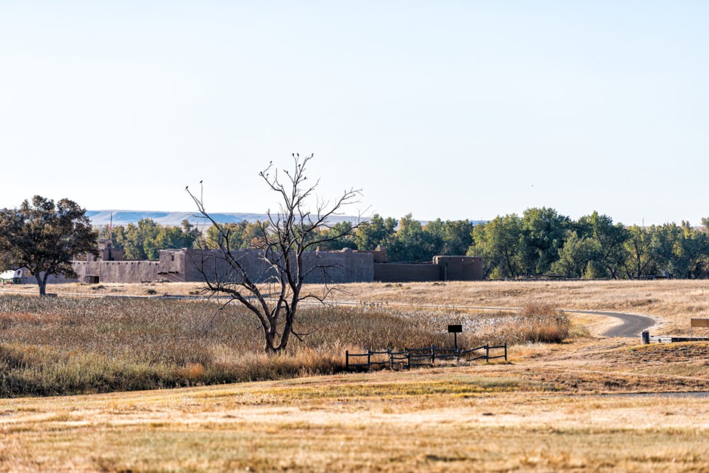
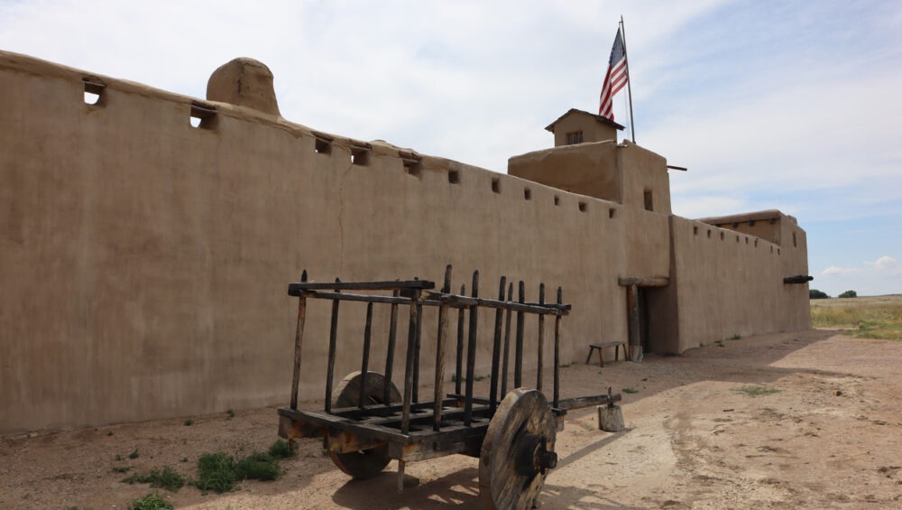
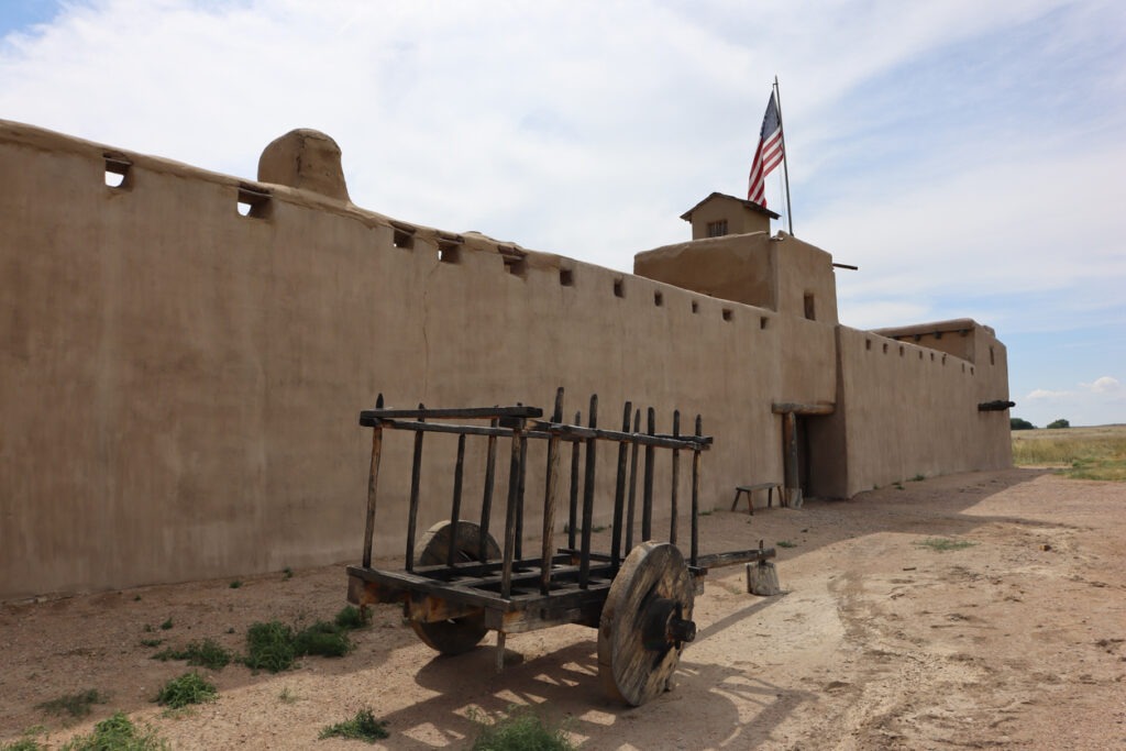
If you’ve ever wanted to experience the sights, sounds, and stories of the American frontier, Bent’s Old Fort National Historic Site is your chance to step into the 1800s. Located in southeastern Colorado near La Junta, this meticulously reconstructed adobe fort served as a trading hub, cultural crossroads, and military post along the historic Santa Fe Trail.

Today, it stands as a living history museum—complete with costumed interpreters, live demonstrations, and immersive storytelling—that lets visitors walk the same pathways as trappers, traders, Native American tribes, and U.S. Army soldiers once did.

Please Note: The reconstructed Fort is currently CLOSED due to safety concerns. Learn more here: https://www.nps.gov/beol/planyourvisit/fort_status.htm


A Trading Post with a Storied Past

Originally built in 1833 by brothers William and Charles Bent, the fort quickly became one of the most important trading centers in the Southwest. Strategically placed along the Santa Fe Trail, it connected commerce between Native American nations, Mexican traders, and American pioneers. It was also one of the few permanent white settlements on the Plains during that time.

Bent’s Old Fort served many roles. It was a trade center for buffalo robes, livestock, tools, and textiles. It was a meeting place for diverse cultures including the Cheyenne, Arapaho, and Kiowa tribes. Finally, it was a military supply depot during the U.S. war with Mexico in 1846

The fort was abandoned in 1849 and eventually fell into ruin, but thanks to detailed sketches, journals, and archaeological work, the National Park Service rebuilt the fort in 1976 on its original footprint.

📍 Location:
35110 State Highway 194
La Junta, CO 81050
Google Maps Directions


What to Expect When You Visit

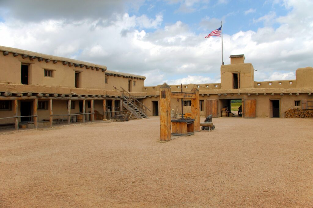
Visiting Bent’s Old Fort is like walking straight into a living history book. The site is fully interactive, engaging, and welcoming to families, school groups, road-trippers, and history buffs alike.

Highlights Include:

  • Furnished rooms and working spaces just as they would have appeared in the 1840s
  • Costumed interpreters demonstrating blacksmithing, cooking, trapping, and trading
  • Live animals such as oxen, chickens, and horses that add to the authentic atmosphere
  • Guided and self-guided tours available throughout the day
  • Special events and reenactments throughout the year
  • A scenic 1.5-mile trail along the Arkansas River with interpretive signs

Admission is free, and the park is open year-round (except major holidays). Hours vary seasonally—check the official NPS hours & info page before visiting.


Tips for Making the Most of Your Trip

To fully enjoy your time at the fort, here are some tips to keep in mind:

  • Wear comfortable shoes – The fort’s grounds include dirt paths and uneven surfaces.
  • Bring water and sun protection – Especially during warmer months; southeastern Colorado can be hot and dry.
  • Pack snacks or lunch – There’s no café onsite, but picnic tables are available near the parking area.
  • Time your visit with a special event – Reenactments and seasonal festivals bring extra life to the fort. Check the calendar of events.
  • Visit nearby La Junta – For local dining and lodging options. Visit La Junta is a great resource for trip planning.

Perfect for Families and Road Trips

Bent’s Old Fort makes a great stop on a Colorado road trip, especially if you’re traveling between Colorado Springs and southeastern Colorado or headed toward the Santa Fe Trail Scenic and Historic Byway.

This park is ideal for families because of the interactive learning makes history fun and hands-on. There is plenty of space for kids to explore safely. The park also offers a unique blend of education, culture, and storytelling that sticks with kids and adults alike.

📚 Educators and homeschoolers can also access classroom resources and field trip opportunities through the National Park Service.


Nearby Attractions to Explore

If you’re in the area, consider adding these stops to your itinerary:


Step Into the Past at Bent’s Old Fort

Whether you’re a history enthusiast, curious traveler, or parent looking for an unforgettable day trip, Bent’s Old Fort National Historic Site brings the Old West to life in a way that’s authentic, immersive, and engaging. You don’t just learn history here—you feel it in the walls, hear it in the creak of wagon wheels, and see it in every fire-blackened cooking pot and weathered adobe brick.

Start planning your visit today: https://www.nps.gov/beol/index.htm

Step Into the Past: Exploring the Remarkable Ruins of Hovenweep

Tucked away in the remote desert landscape along the Colorado–Utah border, Hovenweep National Monument is one of the Southwest’s most fascinating and under-visited archaeological sites. Home to mysterious, towering stone structures built over 700 years ago by the Ancestral Puebloans, Hovenweep offers a rare opportunity to walk among the remnants of an ancient civilization—without the crowds found at more famous sites like Mesa Verde.

If you’re looking for a quieter, off-the-beaten-path experience rich in history, natural beauty, and cultural significance, Hovenweep is well worth the journey. Here’s everything you need to know to plan your visit and explore this captivating monument.


Where Is Hovenweep National Monument?

Hovenweep straddles the border of southeastern Utah and southwestern Colorado, located about:

  • 45 miles from Cortez, Colorado
  • 90 miles from Moab, Utah
  • 115 miles from Durango, Colorado
  • 300 miles from Colorado Springs

The closest town with basic services is Bluff, Utah, though many visitors stay in Cortez or Blanding, Utah and make a day trip to the park.

📍 Visitor Center Address:
Hovenweep National Monument
Montezuma Creek–Hovenweep Road
Montezuma County, Colorado / San Juan County, Utah
Google Maps Location


What Makes Hovenweep Special?

Hovenweep means “deserted valley,” a fitting name for this remote and quiet place, yet it was once a vibrant home to hundreds of Ancestral Puebloans. Unlike the cliff dwellings at Mesa Verde, the structures at Hovenweep were built above ground, often right on the edges of deep canyons.

What sets Hovenweep apart is its architecture and setting. The towers—some circular, some square, others D-shaped—were masterfully constructed using local sandstone, fitted together with such precision that many still stand after centuries of exposure to the elements.

These buildings likely served a mix of ceremonial, residential, and defensive purposes, and many align with solar and lunar events, highlighting the Puebloans’ deep understanding of astronomy.


Main Sites to Explore

Hovenweep National Monument consists of six separate units, but the main and most accessible one is the Square Tower Group near the visitor center. Most visitors focus their time here, but the outlying units are worth exploring if you have extra time and a high-clearance vehicle.

1. Square Tower Group

  • Location: Next to the visitor center
  • Trail: 2-mile loop
  • Highlights: Square Tower, Hovenweep Castle, Twin Towers, Hovenweep House
  • Trail Difficulty: Moderate (some rocky terrain and elevation changes)

This is the best place to get a full view of the site’s scale, complexity, and beauty. The loop trail offers close-up views of the structures, interpretive signs, and stunning views of the surrounding canyon.

2. Outlying Sites (More Remote)

These additional units are less developed and require driving on rough roads, but they offer a more rugged experience:

  • Holly Group
  • Hackberry Group
  • Cutthroat Castle
  • Cajon Group
  • Goodman Point (in Colorado)

📍 Learn more about each site: https://www.nps.gov/hove/planyourvisit/things2do.htm

Eroded Boulder House, Hovenweep National Monument.

How to Get There

Because Hovenweep is remote, you’ll need your own vehicle, and GPS can be unreliable. It’s best to bring printed directions or download offline maps. Roads to the visitor center are paved, but the access roads to outlying units are unpaved and often require high-clearance or 4WD vehicles, especially after rain.

🗺️ Driving directions: https://www.nps.gov/hove/planyourvisit/directions.htm


When to Visit

Hovenweep is open year-round, but the best seasons are spring (April–May) and fall (September–October) when temperatures are mild.

Weather Considerations:

  • Summer: Can reach over 100°F; not ideal for hiking midday
  • Winter: Cold, with occasional snow and icy trails
  • Spring/Fall: Best weather for hiking and photography

🎟️ Entrance Fee: Free


Things to Know Before You Go

Bring Water

There is no water available on the trails. Bring at least 1–2 liters per person, more in summer.

Pack Snacks and Sunscreen

There are no concessions or food options within the monument. Pack high-energy snacks, wear sun protection, and consider a hat and sunglasses.

Wear Appropriate Footwear

Sturdy hiking shoes are recommended for the uneven, rocky terrain.

Check Trail Conditions

Flash floods and storms can make some trails hazardous. Always check current conditions at the NPS website or at the visitor center.

Cell Service Is Limited

Be prepared to disconnect—and enjoy the solitude.


Camping and Nearby Lodging

🏕️ Hovenweep Campground

🛏️ Nearby Lodging Options:


Other Nearby Attractions

If you’re exploring the Four Corners area, Hovenweep pairs well with other nearby destinations:


Why Hovenweep Should Be on Your Itinerary

Hovenweep may not have the name recognition of Mesa Verde or Arches, but that’s part of its charm. It’s a place where you can stand in silence, surrounded by centuries-old towers, and feel the weight of history and mystery in the air.

Whether you’re into archaeology, photography, hiking, or just exploring places few others do, Hovenweep delivers. It’s a destination that invites reflection and leaves a lasting impression.

Ready to explore one of the Southwest’s best-kept secrets? Hovenweep is waiting.

Black Canyon of the Gunnison: Colorado’s Hidden Gem

Tucked away in western Colorado, Black Canyon of the Gunnison National Park is one of the most awe-inspiring yet underrated national parks in the country. With sheer cliffs plunging over 2,700 feet, some of the steepest rock walls in North America, and breathtaking viewpoints, this park offers a dramatic and unforgettable landscape.

While it may not be as famous as Rocky Mountain or Yellowstone, Black Canyon of the Gunnison delivers an experience that’s equally spectacular—without the crowds. Whether you’re a hiker, photographer, rock climber, or just a nature lover, this park is a must-visit destination in Colorado.


Getting to Black Canyon of the Gunnison

Location & Entrances

Black Canyon of the Gunnison National Park is located in western Colorado, about:

  • 1 hour from Grand Junction
  • 2.5 hours from Aspen
  • 4.5 hours from Denver
  • 5 hours from Colorado Springs

The park has two main entrances:

  • South Rim Entrance (near Montrose, CO) – The most popular and easily accessible side, with visitor centers, campgrounds, and numerous overlooks.
  • North Rim Entrance (near Crawford, CO) – A more remote and rugged experience, with fewer visitors and stunning viewpoints.

Entry Fees

  • $30 per vehicle (valid for 7 days)
  • $15 per individual (hiker or cyclist)
  • $55 annual Black Canyon pass
  • America the Beautiful Pass ($80 for access to all U.S. National Parks)

Check current conditions before you go: https://www.nps.gov/blca/planyourvisit/conditions.htm


Best Viewpoints in Black Canyon of the Gunnison

The canyon’s steep cliffs and narrow gorges make for some of the most breathtaking overlooks in Colorado.

Top Viewpoints on the South Rim

  • Gunnison Point – Right next to the South Rim Visitor Center, this is one of the best introductory views of the canyon.
  • Pulpit Rock Overlook – A panoramic view of the canyon’s deepest, narrowest section.
  • Painted Wall View – The tallest sheer cliff in Colorado at 2,250 feet, with dramatic rock streaks that resemble a painting.
  • Chasm View – Offers a look straight down into the narrowest part of the canyon, where the walls are only 40 feet apart.

Best Viewpoints on the North Rim

  • The Narrows View – One of the most dramatic and vertigo-inducing views in the park.
  • Exclamation Point – A hidden gem of the North Rim, offering some of the most breathtaking and isolated views of the canyon.
  • Balanced Rock Overlook – A unique view of a massive boulder perched on the edge of the canyon.

Full list of overlooks: https://www.nps.gov/blca/planyourvisit/scenic-drives.htm


Best Hiking Trails in Black Canyon of the Gunnison

While there aren’t as many trails as in other national parks, the ones here provide epic views and a true sense of adventure.

1. Rim Rock Nature Trail (Easy – 1 mile round trip)

A great introductory hike with stunning views of the Gunnison River and informational signs about the canyon’s geology.

2. Warner Point Nature Trail (Moderate – 1.5 miles round trip)

This short but steep trail takes you to one of the best panoramic viewpoints in the park.

3. North Vista Trail to Exclamation Point (Moderate – 3 miles round trip)

One of the most rewarding hikes, with a must-see viewpoint at Exclamation Point.

4. Gunnison Route (Strenuous – 1.8 miles round trip, 1,800 feet elevation loss)

For serious adventurers, this hike descends into the canyon itself.
A wilderness permit is required, and it’s a steep, rugged climb back up.

More hiking info: https://www.nps.gov/blca/planyourvisit/hiking.htm


Rock Climbing & Adventure Activities

If you’re an experienced climber or backcountry adventurer, Black Canyon of the Gunnison offers some of the most extreme routes in the country.

  • Rock Climbing: The canyon’s sheer walls are famous among advanced climbers, featuring classic routes like “The Scenic Cruise” (5.10) and “Journey Home” (5.11).
  • Fishing: The Gunnison River is one of the best Gold Medal trout fishing spots in Colorado.
  • Kayaking: Only for expert-level kayakers, the Gunnison River offers Class V whitewater rapids inside the canyon.

Climbing regulations and river permits: https://www.nps.gov/blca/planyourvisit/climbing.htm


Camping & Lodging Near Black Canyon

Camping in the Park

  • South Rim Campground – Best for easy access to overlooks and trails.
  • North Rim Campground – A quieter, more remote option.
  • East Portal Campground – Located by the Gunnison River, but closed in winter.

Nearby Lodging

  • Montrose, CO – The closest town with hotels, restaurants, and amenities.
  • Crested Butte, CO – A scenic mountain town with cozy lodges and great hiking nearby.

Campground reservations: https://www.recreation.gov/


Tips for Visiting Black Canyon of the Gunnison

  • Arrive Early – The park is less crowded than other national parks, but parking at popular viewpoints fills up quickly.
  • Dress in Layers – The canyon can be hot during the day and chilly at night.
  • Bring Plenty of Water – There are few water sources inside the park.
  • Watch for Wildlife – Keep an eye out for mule deer, golden eagles, and even black bears.
  • Stay on Trails – The canyon’s cliffs drop off suddenly, so stay on designated trails.

Why You Should Visit Black Canyon of the Gunnison

If you’re looking for jaw-dropping views, adventure, and solitude, Black Canyon of the Gunnison is a must-visit. It’s one of Colorado’s most underrated national parks, offering incredible hiking, breathtaking viewpoints, and a sense of wild, untouched beauty.

Whether you’re standing at the edge of Painted Wall, hiking to Exclamation Point, or venturing into the canyon itself, this park will leave you speechless.

Ready to explore Colorado’s most dramatic landscape? Plan your trip today!

Why Some Visitors Leave Mesa Verde Disappointed (And How to Make Sure You Don’t!)

Nestled in the southwest corner of Colorado, Mesa Verde National Park offers an extraordinary glimpse into the lives of the Ancestral Puebloans who inhabited the region over 700 years ago. This UNESCO World Heritage Site is home to some of the best-preserved cliff dwellings in North America, as well as scenic overlooks, fascinating hikes, and guided tours that bring history to life.

Whether you’re a history enthusiast, an outdoor adventurer, or simply looking for breathtaking views, Mesa Verde National Park is a must-visit destination. Here’s everything you need to know to make the most of your journey through ancient history.


Getting to Mesa Verde National Park

Location & Directions

Mesa Verde National Park is located in southwestern Colorado, about:
📍 1 hour from Durango, CO
🚗 1.5 hours from Farmington, NM
🛣 4 hours from Colorado Springs
✈️ 7 hours from Denver

The park entrance is off Highway 160, near Cortez, CO. From the entrance, it takes about 45 minutes to reach the cliff dwellings, as the main road winds through scenic mesas and canyons.

Best Time to Visit

  • Spring (April–June): Mild temperatures, fewer crowds, and great hiking conditions.
  • Summer (July–August): Hot but lively, with full access to ranger-led tours. Book tickets in advance!
  • Fall (September–October): Cooler weather and stunning fall colors make this a fantastic time to visit.
  • Winter (November–March): A quiet and unique experience, though many cliff dwellings are closed due to snow and ice.

👉 Check the latest park conditions and tour availability: https://www.nps.gov/meve/planyourvisit/conditions.htm


Top Things to Do at Mesa Verde National Park

1. Take a Guided Tour of the Cliff Dwellings

The cliff dwellings are the highlight of Mesa Verde, and the best way to experience them is on a ranger-guided tour. These tours provide historical insights and allow you to walk through the ancient structures.

Best Cliff Dwelling Tours:

Cliff Palace – The largest and most famous cliff dwelling in the park. Expect steep steps and ladders!
Balcony House – An adventurous tour with tunnels and ladders for those who love a challenge.
Long House – A less crowded but equally stunning dwelling on Wetherill Mesa.

🎟️ Tickets are required for guided tours and sell out fast! Book yours at: https://www.recreation.gov


2. Explore the Scenic Drives & Overlooks

Even if you’re short on time or prefer a more relaxed experience, Mesa Verde has stunning viewpoints you can enjoy from your car or short walks.

Mesa Top Loop Road (6 miles) – A self-guided driving tour with 12 stops, showcasing pit houses, ancient kivas, and stunning canyon views.
Sun Point Overlook – One of the best spots to see multiple cliff dwellings in one panoramic view.
Park Point Fire Lookout – The highest point in the park (8,572 feet), offering incredible sunset views over the Four Corners region.


3. Hike Through History

Mesa Verde offers a variety of hiking trails, from easy walks to moderate backcountry adventures.

Petroglyph Point Trail (2.4 miles round trip) – A moderate hike with stunning rock art left by the Ancestral Puebloans.
Spruce Canyon Trail (3.1 miles round trip) – A great way to explore the natural landscape while spotting wildlife.
Step House (1-mile round trip) – One of the few self-guided cliff dwellings, open seasonally.

👉 Check trail conditions before you hike: https://www.nps.gov/meve/planyourvisit/hiking.htm

Soda Canyon Overlook, Mesa Verde National Park

4. Visit the Chapin Mesa Archaeological Museum

Before heading into the park, stop at the Chapin Mesa Museum to learn about Ancestral Puebloan history through artifacts, dioramas, and exhibits.

📍 Location: Near Spruce Tree House & the park’s main visitor area
🎟️ Admission is free!


Where to Stay Near Mesa Verde

In the Park:

  • Far View Lodge – The only hotel inside the park, offering unparalleled views and easy access to sites.

Camping:

  • Morefield Campground – A great spot for RV or tent camping, just 4 miles from the park entrance.

Nearby Towns:

  • Cortez, CO – The closest town, with hotels, restaurants, and grocery stores.
  • Mancos, CO – A charming small town with local shops and lodging options.

Other Nearby Attractions

Canyons of the Ancients National Monument – Home to thousands of ancient ruins, located just 30 minutes from Mesa Verde.
Durango & Silverton Narrow Gauge Railroad – A historic train ride through the San Juan Mountains—perfect for a day trip from Mesa Verde.
Four Corners Monument – Stand in four states at once (Colorado, Utah, Arizona, and New Mexico), about 1.5 hours from the park.

Four Corners Monument, Border of the State of Utah, Colorado, New Mexico, and Arizona, USA – July 26 2018: The Intersection of four states in the southwest of USA. The Four Corners Monument Marking the exact location of the intersection.

Plan Your Mesa Verde Adventure

Mesa Verde National Park is more than just a historical site—it’s a window into the past, a stunning outdoor destination, and an unforgettable experience. Whether you’re climbing through cliff dwellings, hiking scenic trails, or simply taking in the views, this journey through ancient history is one you won’t forget.

Ready to explore? Start planning your trip with Mesa Verde National Park and book your guided tour in advance!

Looking for other National Parks near Colorado Springs? Check out our blog post HERE to get the low down of all the Colorado National Parks!

Great Sand Dunes National Park: A Colorado Wonder

Tucked away in southern Colorado, Great Sand Dunes National Park is a place of surreal beauty and thrilling adventure. Home to the tallest sand dunes in North America, this incredible landscape offers visitors a one-of-a-kind experience where towering dunes meet rugged mountains, alpine lakes, and cascading waterfalls.

Whether you’re looking to sandboard down massive dunes, hike through diverse landscapes, or stargaze under some of the darkest skies in the country, Great Sand Dunes National Park is a must-visit for adventure seekers and nature lovers alike. Here’s everything you need to know to make the most of your trip.

A bright sunny Spring morning view of Medano Creek rushing down a sandy valley at base of rolling Great Sand Dunes and snow-capped Mt. Herard. Great Sand Dunes National Park, Colorado, USA.

Getting to Great Sand Dunes National Park

Location

Great Sand Dunes National Park is located in southern Colorado, about 2.5 hours from Colorado Springs and 4 hours from Denver. The park is easily accessible by car, with well-maintained roads leading to the main entrance.

Best Time to Visit

  • Spring (April–June): The best time to visit if you want to see Medano Creek, a seasonal stream that creates a beach-like oasis at the base of the dunes.
  • Summer (July–August): Expect hot daytime temperatures on the sand but incredible opportunities for nighttime stargazing.
  • Fall (September–October): Cooler weather and fewer crowds make this a fantastic time for hiking and exploring.
  • Winter (November–March): A quieter, more peaceful experience, with the chance to see snow-capped dunes.

Top Things to Do at Great Sand Dunes National Park

1. Sandboarding & Sand Sledding

One of the most exciting ways to experience the dunes is by sandboarding or sand sledding. Similar to snowboarding, this activity lets you ride down the sandy slopes for an adrenaline rush like no other.

💲 Where to rent gear: You can’t rent boards inside the park, but several local outfitters, like Oasis Store, offer rentals just outside the entrance.

🛷 Best dunes for sandboarding: The first ridges near the main parking area are ideal for beginners, while High Dune and Star Dune offer thrilling rides for the more adventurous.

👉 Pro tip: Sand can get extremely hot in the summer—go early in the morning or in the evening for cooler temperatures. Don’t forget your water!

Alamosa County, Colorado, USA – July 11, 2021 – A woman sitting on a sandboard watches fellow tourists at Great Sand Dunes National Park enjoy sandboarding down the dunes of the namesake recreation area.

2. Hiking the Dunes

Unlike traditional trails, hiking at Great Sand Dunes means trekking up and down shifting sand. It’s tough, but the views from the top are worth it!

Best Dune Hikes:

  • High Dune (2.5 miles round trip) – A challenging but rewarding hike to the top of a 699-foot dune.
  • Star Dune (8 miles round trip) – The tallest dune in North America at 750 feet. Expect a strenuous trek with stunning panoramic views.

👉 Hiking Tips:

  • Wear sturdy shoes (barefoot hiking can be too hot in summer).
  • Start early in the morning or go at sunset to avoid the midday heat.
  • Bring plenty of water—the sand reflects heat and can get extremely warm!

3. Medano Creek: The Park’s Natural Beach

One of the most unique features of Great Sand Dunes is Medano Creek, which flows seasonally at the base of the dunes in spring and early summer. This shallow, refreshing stream creates a perfect place to cool off, splash around, or even float on small inflatables.

👉 When to visit: Peak flow typically happens from late May to early June. By mid-summer, the creek begins to dry up. Be prepared for large crowds later in the day and on weekends.

👉 What to bring: Water shoes, a beach towel, and maybe even a small inner tube for floating. Make sure to take into account a fair amount of walking if you arrive later in the day.


4. Zapata Falls: A Hidden Gem Nearby

Just 10 miles from the park entrance, Zapata Falls is a beautiful 30-foot waterfall hidden inside a narrow canyon.

👉 How to get there: Take a short but rocky 0.8-mile round-trip hike from the trailhead. In the summer, you’ll need to wade through shallow water to reach the falls, while winter visitors might see a frozen waterfall!

👉 Why visit? It’s a great place to cool off after a day on the dunes and offers stunning views of the San Luis Valley.

Zapata Falls Canyon Waterfall Scenic – Man hiking in frozen waterfall area with water flowing. Great Sand Dunes, San Luis Valley, Colorado USA.

5. Stargazing in the Dark Sky Park

Great Sand Dunes National Park is a certified International Dark Sky Park, meaning it has some of the clearest night skies in the country. On a clear night, you’ll see thousands of stars, the Milky Way, and even meteor showers. If you are brave enough, you can also camp on the dunes! Make sure to check in with the visitor’s center to familiarize yourself with the rules and regulations.

👉 Best spots for stargazing:

  • The Dunes Parking Area – Offers wide-open views and an easy place to set up a blanket or telescope.
  • Mosca Pass Trailhead – A quieter option with minimal light pollution.
  • Medano Creek – Reflects the stars for a magical experience.

👉 Best times to stargaze: Late summer and fall provide long, dark nights with incredible visibility.


Additional Tips for Visiting Great Sand Dunes

  1. Bring plenty of water – The high elevation and dry conditions can lead to dehydration quickly.
  2. Protect your feet – Sand temperatures can reach 150°F in summer—wear closed-toe shoes or visit in the morning/evening.
  3. Watch the weather – Sudden thunderstorms can roll in, so keep an eye on the sky.
  4. Pack snacks and sun protection – There’s limited shade and few food options inside the park.
  5. Drive carefully on Medano Pass Primitive Road – If you’re exploring beyond the dunes, you’ll need a high-clearance 4WD vehicle for deep sand sections.

Why You Should Visit Great Sand Dunes National Park

If you’re looking for a truly unique adventure in Colorado, Great Sand Dunes National Park is the place to go. Whether you’re racing down dunes on a sandboard, cooling off in Medano Creek, or hiking to hidden waterfalls, this park offers something for everyone.

For those staying in Colorado Springs, this epic day trip (or weekend getaway) is well worth the drive. And if you’re seeking even more adventure, consider booking a guided outdoor experience with Broadmoor Outfitters to explore Colorado’s best hiking, biking, and outdoor activities.

So, pack your gear, grab your camera, and get ready to experience one of Colorado’s greatest natural wonders!

A deer stands in front of Colorado’s great Sand Dunes National Park with the Sangre de Cristo mountains in the background